The OIP system was developed by Geoprobe for the detection of NAPL hydrocarbon fuels, oils, and tars present in the soil. NAPL may be detected as layers, ganglia, blebs or droplets of product in the formation matrix. Compounds in the NAPL will fluoresce when exposed to certain types of light. The tool operates by focusing a light source through a sapphire window and then capturing the resulting fluorescence with a camera 30 times per second as the tool is pushed downward. Back at the technician’s station above ground, a software filter is applied to measure the amount of fluorescence in each image and a vertical log is generated in real-time.
In addition to the NAPL fluorescence measurement, the tool includes an integrated electrical conductivity (EC) array and a Hydraulic Profiling Tool (HPT). The EC array measures bulk formation conductivity which can be used to make inferences about the soil type encountered. The HPT measures back pressure and flow rate of injected water to generate an estimated soil transmissivity value. Together, these tools provide a powerful collaborative data set for understanding hydrostratigraphy. Cascade deploys both of the light sources available from Geoprobe: the OIP-UV and OIP-G.
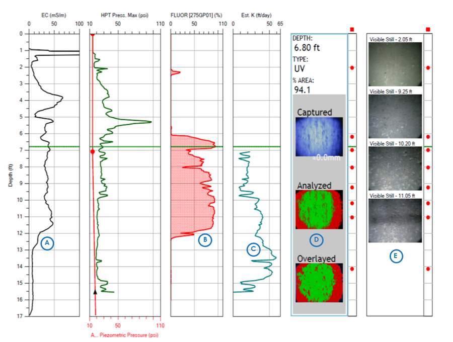
OIP Log Generated by Cascade HRSC Team - This log shows the multiple data sets created during advancement of the OIP tool in the subsurface, including electrical conductivity (A); percent areal fluorescence (NAPL detection)(B); estimated hydraulic conductivity (C); UV light and software filtered images from a selected depth: in this case 6.8 feet below ground surface (D); and visible light images from selected depth (E).
The OIP-UV probe uses a UV LED and visible light camera and is suitable for the delineation of fuels such as gasoline, diesel, etc. In addition to the software-filtered images showing percent areal fluorescence, the OIP-UV also provides the client with full-color images of the soils outside the probe window.
The OIP-G probe uses a green laser diode and an infrared camera, ideal for delineating coal tars, creosote, and heavy fuels or oils. Since this system uses an infrared camera to filter out the green light, the visible light images returned by this probe are in black and white.
Data is collected and viewed in real-time on a computer, visible to the entire field team. In addition to the boring logs, an electronic data deliverable (spreadsheet-based) is created that is suitable for incorporation into common database tools (e.g., EQuIS) and for use in three-dimensional modeling software, such as EVS. Cascade also offers near-real-time data transfer via online mapping tools such as ArcGIS and can assist you in interpreting HRSC data.

Have general inquiries about Cascade and our Services?
Contact UsLooking for a quote?
Request A QuoteIdeal for drilling where undisturbed core sampling is required
Ideal for unconsolidated alluvial deposits like sand, silts and clays
Ideal for hard and soft lithology with multiple rotary methods available.
Ideal for smaller sites and produces less waste with more samples